


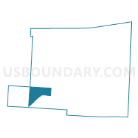
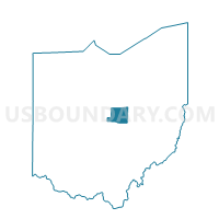
MILFORD A Voting District, Knox County, Ohio
About
Outline

Summary
| Unique Area Identifier | 648210 |
| Name | MILFORD A Voting District |
| County | Knox County |
| State | Ohio |
| Area (square miles) | 13.62 |
| Land Area (square miles) | 13.58 |
| Water Area (square miles) | 0.05 |
| % of Land Area | 99.65 |
| % of Water Area | 0.35 |
| Latitude of the Internal Point | 40.32761180 |
| Longtitude of the Internal Point | -82.60131220 |
Maps

Graphs
Select a template below for downloading or customizing gragh for MILFORD A Voting District, Knox County, Ohio


Neighbors
Neighoring Voting District (by Name) Neighboring Voting District on the Map
- CLINTON B Voting District, Knox County, OH
- HILLIAR A Voting District, Knox County, OH
- HILLIAR B Voting District, Knox County, OH
- LIBERTY B Voting District, Knox County, OH
- MILFORD B Voting District, Knox County, OH
- MILLER Voting District, Knox County, OH
- S BLOOMFIELD TWP E, Morrow County, OH
Top 10 Neighboring County Subdivision (by Population) Neighboring County Subdivision on the Map
- Hilliar township, Knox County, OH (3,715)
- Clinton township, Knox County, OH (2,826)
- Milford township, Knox County, OH (1,772)
- South Bloomfield township, Morrow County, OH (1,752)
- Liberty township, Knox County, OH (1,716)
- Miller township, Knox County, OH (1,006)
Top 10 Neighboring Unified School District (by Population) Neighboring Unified School District on the Map
- Mount Vernon City School District, OH (30,960)
- Highland Local School District, OH (10,233)
- Northridge Local School District, OH (8,412)
- Centerburg Local School District, OH (6,411)